Petroleum, oil and gas, or hydrocarbon exploration, is the search by petroleum geologists and geophysicists for sedimentary basins beneath the Earth’s surface. Sedimentary basins are areas where large sections of porous rock, known as sedimentary rock, is present. Exploration is generally concentrated in sedimentary basins which can occur beneath the seabed and on land. In recent years petroleum exploration for deep, offshore sedimentary basins has been rising. Petroleum exploration consists of two stages, the location of oil and gas deposits, and the drilling of exploration wells.
1st Stage of Exploration
- The first stage of exploration involves locating a sedimentary basin, this is done by gathering surface and subsurface clues that suggest the presence of oil and gas.
- Surface clues (such as oil and natural gas seeps, and certain geological formations) can be gathered by mapping the surface from airplanes, satellites, or ships. These clues, while still helpful, aren't how most sedimentary basins are discovered.
- Subsurface clues (such as the geological structures and the properties of rocks beneath the surface) usually provide more information than surface clues.
- Both surface and subsurface clues are gathered through a variety of techniques such as geochemical sampling, geological mapping, and seismic, radiometric, controlled electro-magnetic (EM), geomagnetic and gravity surveys.
Geochemical Sampling:
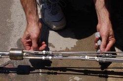
Part of a chemical sampling device.
- Geochemical sampling is the collection and analysis of various types of geological material such as soil, stream sediment and rocks. In these materials geologists and geophysicists look for traces of hydrocarbon to locate basins.
- Land surveys are done by analysing samples of geological material which has been collected by putting a chemical sampling device in the ground.
- Sea surveys are done by analysing sediment from the seabed, which has been collected with a coring tool and put into a jar with a sampling device.
- These sampling units are used in grids to cover large areas.
Geological Mapping:
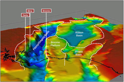
Geological map of the canning superbasin in Western Australia.
- Geological maps are used to show geological features such as rocks on a map. This helps in the location of sedimentary basins as it helps determine wether sedimentary rocks are present.
- Geologists create geological maps by either using individually, or combing aerial photographs, and detailed topographic maps.
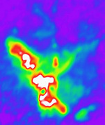
Seismic Surveys
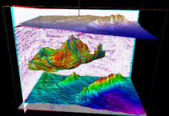
3D seismic map of offshore Nigeria.
- Seismic surveys are done by sending high-energy sound/shock waves into the ground, and measuring how long it takes for them to reflect back to the surface with sensitive microphones or vibration detectors.
- If the location is over water the shock waves are created by a compressed air gun or explosives, if it is over land a vibroseis truck or explosives are used.
- This seismic data is then feed into a computer which creates a 3D map of what lies below the surface. The computer can do this because sound travels at different speeds through different materials.
- Geologists and geophysicists use these 3D maps to look for sedimentary rock.
- Seismic surveys are the main tool used in oil and gas exploration.
Geomagnetic Surveys
|
 Geomagnetic survey being conducted from a helicopter. |
Gravity Surveys
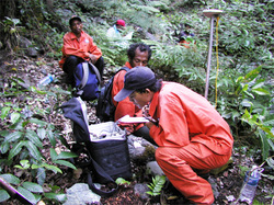 Gravity survey being conducting by a team of geologists in the jungle. |
|
Radiometric Surveys
 Radiometric survey conducted from an airplane. |
|
|
 A controlled electro-magnetic survey being conducted by a helicopter. |
2nd stage of exploration.
- When the data indicates a likely site for sedimentary rock, an exploration well is often drilled.
- Until the drilling begins there is no guarantee there is oil.
- From the drill, rock samples are brought to the surface and well logs measure the electrical, magnetic and radioactive properties of the rocks.
- By examining this information geologists can determine if the site is going to produce oil and gas in economic quantities.
